I completed the below paper in September 2019 for my Honours degree in History at the University of Melbourne. The assessment task was to design a thematic exhibition - with a range of artefacts and accompanying descriptions - centred on an aspect of the course ‘The Long History of Globalisation’. I chose the topic of ‘The Silk Road’, inspired by this fascinating journal article by Kodadad Rezakhani, which argued for a more expansive and inclusive understanding of global trade and interconnectivity.
***
What could a combination of the First Edition of Encyclopaedia Britannica, a photo of a Chinese Terracotta Warrior, a Persian carpet, an Islamic-Iberian silk fragment, and an indigenous-Australian bark painting possibly have to do with one another, let alone the history of globalization?
The answer to this question begins with and hinges on the Encyclopaedia, which rests open at the definition of ‘Silk Road’:
Silk Road, also called Silk Route: ancient trade route that linking China with the West, carried goods and ideas between the two great civilisations of China and Rome. Silk came westward, while wools, gold, and silver went east.
Coined in 1877 by German geographer Baron Ferdinand von Richthofe, the term ‘Silk Road’ has been the source of much debate in certain academic circles. This is because the very notion of the Silk Road imposes a re-imagined and idealised modern concept on the past, with little bearing on the complexities of the historical reality across millennia. In this way, we can see how language and definitions – even those in trusted sources such as the Encyclopaedia Britannica - can circumscribe or distort understandings about nuanced historical events and phenomena. The photo of the Terracotta Warrior – discovered at Xi’an, the Eastern point of the Silk Road - speaks to this romantic historical narrative about the silk trade between East and West.
One of the main critiques of the Silk Road as a definition and a historical concept is that way it eclipses the full picture of the spatial realities of the global silk trade. For example, in the Encyclopaedia’s definition, Iranian civilization is elided over as a non-descript place between “China with the West” or “the two great civilisations of China and Rome”. This ignores the geopolitical, cultural and economic significance of Iranian civilization entirely. The inclusion of the Persian carpet highlights the importance of Iran and other Central Asian nations as manufacturers of silk products, while also emphasising the diversity of the silk supply chain beyond China, which came to Safavid Iran from countries such as Syria and Lebanon.
Indeed, the conventional notion that the silk trade was unidirectional from China to the West (or Rome) is overly simplistic. The silk ‘Textile Fragment’ adds to our understanding of the multiplicity of ways in which silk spread throughout Europe from the Iberian Peninsula, where it was produced by artisans in the Islamic-Iberian caliphates from roughly 800 CE until the fall of the Nasrid Dynasty in 1492 CE.
This theme of recognising these ‘invisible’ trade routes at the peripheries of grand historical narratives is also demonstrated through the indigenous-Australian bark painting Makasar Prau. This artwork testifies to the existence of a centuries-old maritime and land trade route between indigenous Australians, Southeast Asian Macassan traders, and the Chinese people, where cotton and other textiles were exchanged for norther Australian trepang (sea cucumber). It also resonates with the Encyclopaedia Britannica as an alternate, non-European means of communicating knowledge, memory and history within society and intertemporally.
Each object included in the display is strongly associated with a national identity, be it British, Chinese, Dhalwaŋu, Iranian or Islamic-Iberian. The phenomena which bind together each of these temporally and geographically disparate objects are the invisible forces of economic trade, its associated networks across land and sea, and its mechanisms of exchange. In this sense, the practice of the history of globalisation can help us to ‘connect the dots’ and develop more balanced, nuanced accounts of history and an appreciation for the complex forces which shape it.
Encyclopaedia Britannica
First Edition, 1771, Volume 3, (open at the definition of “Silk Road”)
National Library of Scotland
Smellie, William, 1740-1795
Edinburgh: Printed for A. Bell and C. Macfarquhar; and sold by Colin Macfarquhar, 1771.

Encyclopaedia Britannica
The first edition of Encyclopaedia Britannica was published in 1768 in Edinburgh, Scotland. Instructively, it takes its name from the Latin ‘encyclopaedia’, which means ‘general education’, and ‘Britannica’, meaning ‘British’. As the world’s oldest English-language general encyclopedia, it represented the most systematic and comprehensive effort of English-speaking peoples to compile human knowledge in one academic, reputable, peer-reviewed source. Upon publication of the First Edition on 10 December 1768, an advertisement in Edinburgh’s local press announced that the Encyclopaedia would provide “accurate definitions and explanations” on a range of subjects spanning the arts and sciences.
The Encyclopaedia Britannica of 1768 was not a novel concept. Records of similar encyclopaedic works date back to Ancient Rome, with Pliny the Elder’s Naturalis Historiae comprising 37 chapters replete with factual details and extensive explanations of the world he inhabited, covering subjects as diverse as geography, medicine, the arts, and natural history. In the 18th century, the three volume First Edition of Encyclopaedia Britannica was preceded and eclipsed in scope and depth by the 17-volume French Encyclopédie (1751) and the 64-volume German Great Complete Universal Lexicon (1732).
The re-emergence of the encyclopedia as an academic and cultural phenomenon in the 18th century is closely associated with the Age of Enlightenment, a global intellectual and philosophical movement with roots in Europe and the fertile intellectual grounds of the Renaissance, which in turn harked back to antiquity as a source of inspiration for the modern, industrialising world. Proponents of the Enlightenment valued reason, factual accuracy and the scientific method as the foundation of all knowledge, rather than superstition, tradition and religion.
Photo of Kneeling Soldier
Qin dynasty, 221-207 BCE
Earthenware
Emperor Qin Shihuang’s Mausoleum Site Museum, Xi’an, China.

Kneeling Soldier, Terracotta Army
This is a photo of one of the thousands of terracotta warriors standing guard in the Mausoleum of Emperor Qin Shi Haungdi, protecting him in the afterlife as their models did while living. Unearthed by farmers digging a well north of the Chinese city of Xi’an in 1974, the discovery of the Emperor Qin’s Terracotta Army transformed Xi’an into a major global tourist attraction and generated renewed interest in the histories of Xi’an, Chinese civilisation, and the Silk Road.
Emperor Qin Shi Huangdi was a ruler who conquered and unified the warring Chinese kingdoms, putting an end to the division of the Warring States period, and who initiated construction of the Great Wall of China as a means of protecting his new nation’s northern borders and trade routes. The establishment of the Qin Dynasty from 221-206 BCE helped to instil a unified ethnopolitical conception of the modern Chinese nation and the Han people which endures to this day. Xi’an (Chang’an) was the capital of the Qin dynasty, and has in modern times been identified as the Eastern point of the Silk Road, an ancient and contentiously termed transcontinental trade route connecting Europe and Asia. The term ‘Silk Road’ was coined in 1877 by German geographer Baron Ferdinand von Richthofe. Since as early as 1100 BCE, Xi’an functioned as a cosmopolitan political, diplomatic and economic nexus for various Chinese kingdoms and dynasties, with extensive engagement and trade with the countries and civilizations to its west, without using a term comparable to Silk Road.
Entombed and undiscovered for nearly two millennia, the Terracotta Army is an important symbol for the nature of historical work, where unexpected discoveries can reveal lost worlds and reorient operative historical paradigms. The global fascination with the Terracotta Army also speaks to the grandeur, mystery and power of physical objects in engaging the public and communicating aspects of history.
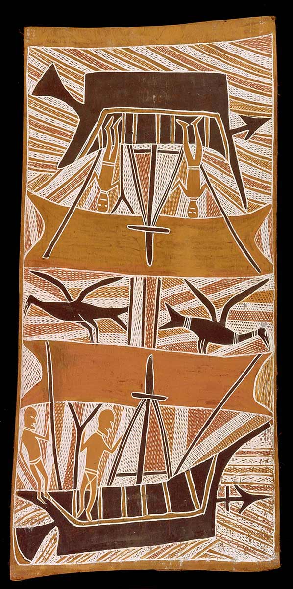
Makasar Prau
1966, bark painting by Birrikitji Gumana, Yirrkala,
96 x 46cm.
National Museum of Australia. Buku-Larrnggay Mulka Art Centre

Makasar Prau, National Museum of Australia. Buku-Larrnggay Mulka Art Centre
Makasar Prau is an indigenous-Australian bark painting, depicting monochromatic sailors with spears in hand aboard wooden sailboats. It was created by Birrikitji Gumana (1890-1982), a community elder of the Dhalwaŋu clan in Eastern Arnhem Land, a region in Australia’s far north pointing towards the Indonesian archipelago. Painted on the smooth interior of native stringybark with natural earth pigments and ochres, Makasar Prau recalls Birrikitji’s childhood memories of interacting with seafaring traders, who visited Australia’s northern shores in the wet season, generally from November to April.
From roughly 1700 CE, traders from Makassar, Indonesia would voyage to Arnhem Land in order to procure trepang (an edible sea cucumber) from the northern Australian coastline. Trepang was highly sought-after in Southeast Asia and China, and these Macassan sailors would exchange metal, cloth and textiles with indigenous Australians for the prized delicacy, in order to sell it to the vast markets to Australia’s north, particularly China, where it was valued for its culinary and medicinal qualities. After the Federation of Australia in 1901, the Government banned Macassan traders from Australia’s territorial waters, reportedly as part of the White Australia Policy. The last Makasar prau visited the ancient shores of Arnhem Land in 1907, bringing an end to centuries of trade and cultural exchange.
This bark painting is significant for many reasons. It represents a cultural medium used to transmit knowledge and memories across generations of inhabitants in Eastern Arnhem Land; it is indicative of long-standing and extensive trade routes connecting indigenous Australians, Southeast Asia and China both culturally and economically; and it hints at the existence of complex, undiscovered histories outside the understanding of dominant cultural and linguistic groups, and prevailing historical narratives and paradigms.
‘Textile Fragment’
Silk, late 14th-early 15th century (Nasrid Dynasty), Spain
The Met, New York, USA

‘Textile Fragment’, The Met, New York, USA
This textile fragment was woven from colourful silk in the late 14th - early 15th centuries in the south of the Iberian Peninsula. It is an artistic product of the Nasrid Dynasty, the longest ruling and last Moorish-Muslim dynasty in the Iberian Peninsula, whose Emirate of Granada covered much of modern-day Andalusia in the south of Spain. The script reads ‘Glory to our lord the Sultan’ in Arabic, indicating the complex religious and political histories of the Iberian Peninsula over the past two millennia.
Large swathes of the Iberian Peninsula were conquered by the Arab-Islamic Umayyad Empire in early 700CE, leading to nearly 8 centuries of Islamic political, economic, linguistic, and religious influence on the peninsula. Recent scholarship suggests that the Islamic caliphates in the south of Spain (al-Andalus) began to produce silk and silken products as early as the 8th century CE. Items such as the ‘Textile Fragment’ were refined and exported from al-Andalus to the Christian kingdoms in the north of the peninsula, either through direct trade for clothing or fashion, as diplomatic offerings, or through religious exchange. Such was the demand for Iberian-Islamic silk throughout continental Europe, that by the eleventh and twelfth centuries the caliphates came to dominate the western-Mediterranean markets for silk and silk products, surpassing the traditional monopoly producers in the Middle East and China.
The existence of such a flourishing silk trade from Western Europe implies that the story of the diffusion of silk in Europe was far more complex than romantic accounts of the Silk Road suggest. In a broader sense, the historical resonances of the ‘Textile Fragment’ encourage us to form a more nuanced and inclusive sense of ‘Western Civilization’.
‘Carpet’
Silk, 16th century, Safavid Empire, Iran
The Met, New York, USA

‘Carpet’, The Met, New York, USA
This decorative carpet comes from the UNESCO World Heritage Site and shrine of Shaikh Safi al-Din, poet and founder of the Safavid Dynasty, which ruled Iran from 1501-1736 CE. Located in Ardabil in modern-day Iran, the shrine is adjacent to the Caspian Sea, situated in the great Trans-Eurasian thoroughfare of Central Asia.
Resplendent in its red, blue, gold and green colours, and woven with Persian-Iranian wool and silk, the carpet typifies the aesthetic of sixteenth century Persian rugs. Beyond their material beauty, these Persian rugs often depicted narratival scenes from Persian poetry and Islamic scripture. The silk cloth used to weave these Persian rugs was imported from nations in all directions around Iran, including Syria, Lebanon and China.
Because of its geography, Iran has been a seat of a rich cultural and economic exchange between Europe and East Asia for millennia. However, the liminal and transcontinental nature of its geography has led to limiting Eurocentric definitions and conceptualisations of the vast expanse of Iran as simply “Eurasia” - a threshold between the “West” and “Asia” – which often elides the cultural, economic and political achievements of Persian/Iranian civilization.
Background Image:
Nova Archipelagi Orientalis Tabula (A New Map of The Eastern Archipelago)
By Blaeu, Willem Janszoon, 1571-1683
National Library of Australia
MAP RM 4701

Nova Archipelagi Orientalis (New Eastern Archipelago), by Willem Janszoon Blaeu
National Library of Australia, and Grimwade Centre for Cultural Materials Conservation, the University of Melbourne
The Blaeu Map ‘Nova Arichipelagi Orientalis Tabula’ (A New Map of the Eastern Archipelago) was constructed in 1663 CE by William Janszoon Blaeu, a famous Dutch cartographer. The image is intended to orient the viewer to key themes about the history of globalization throughout the display. Blaeu produced the map with the support of the Dutch East India Company, the commercial entity involved in Dutch trade, exploration and colonization across Asia. This alludes to the display’s consideration of complex, interconnected and unknown trade networks across land, sea and time. Being a European map about unchartered Asian and Antipodean territories, there are also subtexts about East-West historical and geographical perspectives at play.
The incomplete nature of the map recalls the Latin cartographical term terra incognita or unknown land, prompting the viewer to question ‘unknown to whom?’ Such a phrase has resonances with the term terra nullius, which was a legal principle in international law used by the British to justify the occupation of the Australian continent despite the existence of indigenous nations and societies, which is also a subject considered by the display. At a meta level, the Blaeu map speaks to the way in which all historical work is akin to cartography, with new spaces on blank chart waiting to be discovered and filled in.
Bibliography
Aanavi, Don. 1968. "Western Islamic Art". The Metropolitan Museum of Art Bulletin. 27 (3): 197-203.
Berzock, Kathleen Bickford, Christina M. Nielsen, Janice Katz, Gregory Nosan, Tanya Treptow, Martha Wolff, Elinor Pearlstein, Ghenete Zelleke, Sarah E. Kelly, and Ellen E. Roberts. 2007. "Trade". Art Institute of Chicago Museum Studies. 33 (1): 50-94.
Chin, Tamara. 2013. "The Invention of the Silk Road, 1877". Critical Inquiry. 40 (1): 194-219.
Dimand, M. S. 1932. "A Sixteenth-Century Persian Rug". The Metropolitan Museum of Art Bulletin. 27 (3): 64-66.
“Eastern Arnhem Land”, https://www.nma.gov.au/exhibitions/old-masters/eastern_arnhem_land
FRASER, RUSSELL. 2002. "FLYING HORSES ON THE SILK ROAD". The Virginia Quarterly Review. 78 (4): 595-615.
Neils, Jenifer. 1985. "The Twain Shall Meet". The Bulletin of the Cleveland Museum of Art. 72 (6): 326-359.
Macknight, Charles Campbell. 1986. "Macassans and the Aboriginal past". Archaeology in Oceania -- 1986; 21(1); 69-75 -Bibl.
Macknight, C. C. 2011. "The view from Marege': Australian knowledge of Makassar and the impact of the trepang industry across two centuries". Aboriginal History. 35: 121-143.
May, Catriona, “Restoring One of the World’s Rarest Maps”, https://pursuit.unimelb.edu.au/articles/restoring-one-of-the-world-s-rarest-maps
Metropolitan Museum of Art (New York, N.Y.), and Richard Ettinghausen. 1975. Islamic art. New York: Metropolitan Museum of Art.
"Muslim Art in Spain: Influences and Classifications: Shahid Suhrawardy". 2008. Pakistan Horizon. 61 (1-2): 167-177.
McCarthy, Tom, “Encyclopedia Britannica halts print publication after 244 years”, https://www.theguardian.com/books/2012/mar/13/encyclopedia-britannica-halts-print-publication
Stewart, Donald E., Levy, Michael, Hardy Wise Kent, Christopher, “Encyclopaedia Britannica”, https://www.britannica.com/topic/Encyclopaedia-Britannica-English-language-reference-work
“Rare Map Makes Final Journey Home”, https://ilab.org/articles/rare-map-makes-final-journey-home-blaeu-map-returns-national-library-australia
Rezakhani, Khodadad. 2011. "The Road That Never Was: The Silk Road and Trans-Eurasian Exchange". Comparative Studies of South Asia, Africa and the Middle East. 30 (3): 420-433.
Schilder, Günter. 1971. New cartographical contributions to the coastal exploration of Australia in the course of the 17th century. [Place of publication not identified]: [publisher not identified].
Schroeder, Milton R., and Mary M. Schroeder. 1974. "The New Encyclopaedia Britannica: "All Human Knowledge". American Bar Association Journal. 60 (6): 711-714.
Woods, Dr Martin, “The Blaeu Map Returns”, https://www.nla.gov.au/unbound/the-blaeu-map-returns
Images:
First Object
Encyclopaedia Brittanica, First Edition, 1771, Volume 3, (open at the definition of “Silk Road”)
National Library of Scotland
Smellie, William, 1740-1795
Edinburgh: Printed for A. Bell and C. Macfarquhar; and sold by Colin Macfarquhar, 1771. https://digital.nls.uk/encyclopaedia-britannica/archive/144133903#?c=0&m=0&s=0&cv=0&xywh=-811%2C-145%2C4302%2C3857
Second Object
Photo of Kneeling Soldier
Qin dynasty, 221-207 BCE
Earthenware
Emperor Qin Shihuang’s Mausoleum Site Museum, Xi’an, China, https://whc.unesco.org/en/list/441/gallery/&index=13&maxrows=12
Third Object
Makasar Prau, 1966, bark painting by Birrikitji Gumana, Yirrkala, 96 x 46cm.
National Museum of Australia. Buku-Larrnggay Mulka Art Centre https://www.nma.gov.au/__data/assets/image/0010/546895/nma.img-__davi0009-000-wm-vs1-1400h.jpg
Fourth Object
‘Textile Fragment’
Silk, late 14th-early 15th century, Spain
The Met, New York, USA
https://www.metmuseum.org/art/collection/search/447048
Fifth Object
‘Carpet’
Silk, 16th century, Safavid Empire, Iran
The Met, New York, USA https://www.metmuseum.org/art/collection/search/445995?&exhibitionId=%7b67f03ab5-3930-472a-b12a-f5f20ab10ff1%7d&oid=445995&pkgids=417&pg=1&rpp=4&pos=1&ft=*
Background Image
Archipelagus Orientalis (Eastern Archipelago)
By Blaeu, Willem Janszoon, 1571-1683
National Library of Australia
MAP RM 4701, https://nla.gov.au/nla.obj-232510007/view